

5. May 2020
The web portal 2.0 is finally there!
Like we announced last week, the new web portal 2.0 has been online since yesterday. It improves many existing features and looks stylish as well. The new design builds on the so-called Material Design by Google and allows for a flawless operation on all kinds of devices (computers, tablets and smartphones).
An overview about the 11 most important changes:
- General:
- Two-column-fullscreen layout: In the layout of the new web portal, we no longer have a navigation menu on the left and thus have even more space for what really matters: Mathtrails! All important information is now consistently clustered in the left column while the map finds a home in the right column.
- Mobile layout: Using a mobile device, the two columns are “on top of each other”. Pressing a button located on the bottom right of the screen, you can switch from one view to the other.
- Map search: Using the search field on the map, it is possible to search for streets, cities or countries.
- Favourites: Save your favourite trails and tasks and look them up quickly navigating to the favourites tab.
- Sort and filter tasks and trails: In the list of trails and tasks it is possible to sort all items in an ascending or descending order according to different criteria. Additionally, it is now possible to filter items according to grade, date of creation or text. And, what is even better, the filter will also be applied to all items displayed on the map!
- Mathtrails:
- Restructuring of Mathtrails: The following sub-pages will simplify the creation and use of Mathtrails:
- Edit Mathtrail: Change meta information (description, duration, place) and settings (enable / disable hints etc.) of a trail.
- Edit tasks list: In this area, you can add tasks that are nearby your trail. Tasks that are already part of the trail can be rearranged or removed.
- Digital classroom: The digital classroom has evolved into our favorite feature and as such, now gets its own separate area.
- All sub-pages can be reached via the grey toolbar, once a trail is opened.
- Creating a trail: The creation of a trail is now divided into two steps. In the first step, you create a “shell” for your trail. This shell contains meta information (name, place, description, image) and settings. New to this step is the need to define a center where your trail will roughly take place. To add tasks to your trail, simply open your trail and click on “Edit tasks list”
- The trail carousel: When opening a task from inside a trail, it is now possible to “zap” through the tasks of this trail using the arrows below the grey toolbar.
- Restructuring of Mathtrails: The following sub-pages will simplify the creation and use of Mathtrails:
- Tasks:
- Task drafts: A task draft is meant to quickly capture an idea for a task, for example while not at home. In contrast to the regular task form, you can fill in less fields when in draft mode (only image, position, title, description and tags). To be able to add your draft to a trail, it must be modified later.
- Copy tasks: Sometimes you stumble across a nice task which you would like to also have near you, however, there is no wizard for this task yet. It is now possible to duplicate tasks. By default, this feature is activated for all tasks. However, if you do not want your tasks to be copied, you can disable this feature.
- Digital Classroom :
- Choose from more trails: You can now create a digital classroom for all public trails and not just your own.
- Extend your classroom: While your digital classroom is active, it is possible to extend its duration by up to 30 minutes.
- Push notifications: Activate push notifications to get notified in your browser as soon as a user joins the classroom or sends you a message.
- Multimedia: In the chat in the digital classroom, it is now possible to receive images and audio files. The corresponding app update will come soon.
Further Changes:
- General:
- Main Menu: Forget the old toolbar. The entry point into the webportal is the new main menu. It is made up of tiles which will lead the user to the different areas of the webportal if clicked on. In the future, new content can be added easily to the main menu.
- URL: The URL of all content has changed. Right now, it is not possible anymore to use the old URLs.
- Languages: You can change the language of the webportal via the blue toolbar.
- Profile preview: Every content now contains a profile preview (name, role, level) of its author.
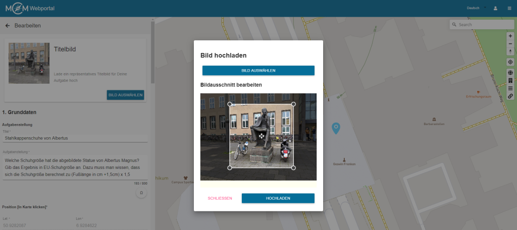
- Optimised image upload: All images are now uploaded via a separate dialog. In the case of cover photos, you need to slice your image so it has a quadratic shape. For all other images, it is elective to slice them. Automatically scaling the image before it gets uploaded, there should be less upload errors.
- Share Content: In the grey toolbar, you will find a share icon which enables you to share content with others. Right now, it is possible to share content with a group. More sharing options will be added in the future.
- State: Tasks and trails now have a section in the left column called „state“. In this section you will find information regarding the completeness of the form, the visibility and the review process.
- My tasks / my trails: In these tabs you will find all content authored by you, independent from the currently visible map section.
- New tab „For me“: This tab contains all content that was shared with you via a group
- New tab „Favourites“: This tab contains all items which the user has marked as “favourite”.
- Public content: In the tab „Public“, not all items will be loaded at once but only those in the currently visible map section and a little more. This helps to optimise performance.
- Mathtrails:
- Mathtrails that do not contain any tasks will be highlighted in the list
- The fields „country“ and „city“ are filled in automatically when creating a trail using so-called reverse geocoding.
- The list of the trails now contains – apart from the code, the place and the number of downloads – also the numbers of tasks in the trail as well as the distance to the current location
- Tasks:
- Task drafts are highlighted in the list of tasks. When they are opened, an additional notification informs you that this is only a draft.
- Copied tasks contain a reference to the original task in the “state” section
- Tasks that were created using the wizard contain a reference to the title of the wizard in the “state” section
- You can open the task wizard when creating a new task by clicking on the magic wand symbol which is located in the grey toolbar
- Tags are separated and confirmed pressing “Enter” and automatically get converted into so-called “chips”
- Groups:
- Groups now contain lists with all shared content. Via the list, it is possible to directly open the respective items
- Reviews:
- Before you are able to submit a task or trail into the review process, you will see a list containing all review guidelines and you must confirm that you are in possession of all image rights
- The list of reviews now also contains information about how long an item has been in the review process
- There are two new tabs “My history” and “History”. Here, it is possible for reviewers to see which and how many tasks or trails they have reviewed so far
Found a bug?
Just email info@mathcitymap.eu!
We are looking forward to your questions, suggestions and comments.


Web portal 2.0 is finally here and it is incredible! Job well done. I have a question. Just after I open the portal, next to my name is an indication of points. What do these points mean and what is their range?
Dear Liina, thank you very much for your praise, we appreciate it!
Concering your question: These “points” are a user’s level which mirrors his or her level of activtiy within the MCM system. The higher your level, the more things you have done within the MCM system. Right now, you can get experience points (EP) creating tasks (100 EP), trails (20EP times the number of tasks in your trail) and for publishing a task or trail (300 EP). When you sign up for MCM as a new user, you start with Level 1. There is no maximum level. However, you can roughly say that someone with level 11 or higher can be considered an expert user. You can get to the next level by accumulating a certain amount of EP. More precisely, you need 200 EP times your current level, so, for example, to get from level 5 to level 6 you need 200EP*5 = 1000 EP.
Hope this answers your question! Feel free to ask more questions if anything is unclear 🙂
I got it. Thank you for the thorough answer.