Create / Edit Trail

A trail comprises several mathematical tasks that are all located near each other. This allows you to walk from one task to the next and work on them one after the other. Here you will find a step-by-step instruction on how to create and edit your own trail:

Portal

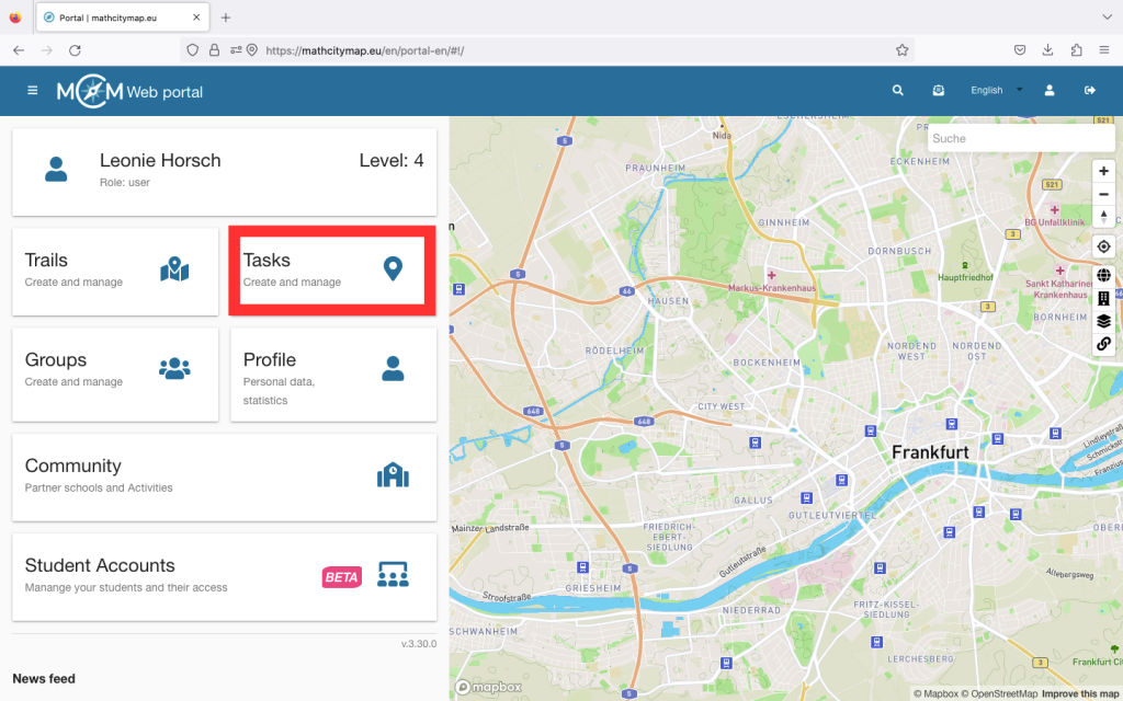
Step 1 – Open trail area

To create your own trail, click on “Trails – Create and manage”. You can also click on “Trails” in the menu bar on the left-hand side.

There is a + symbol at the top left. Click on this to start creating your trail.

The trail will not be saved automatically, so don’t forget to click on “Create” after entering the information.

Step 2 – Specify basic information for the trail

You will now be asked to enter the basic information for your trail. This includes uploading a representative cover image, defining the title and basic information about the trail.

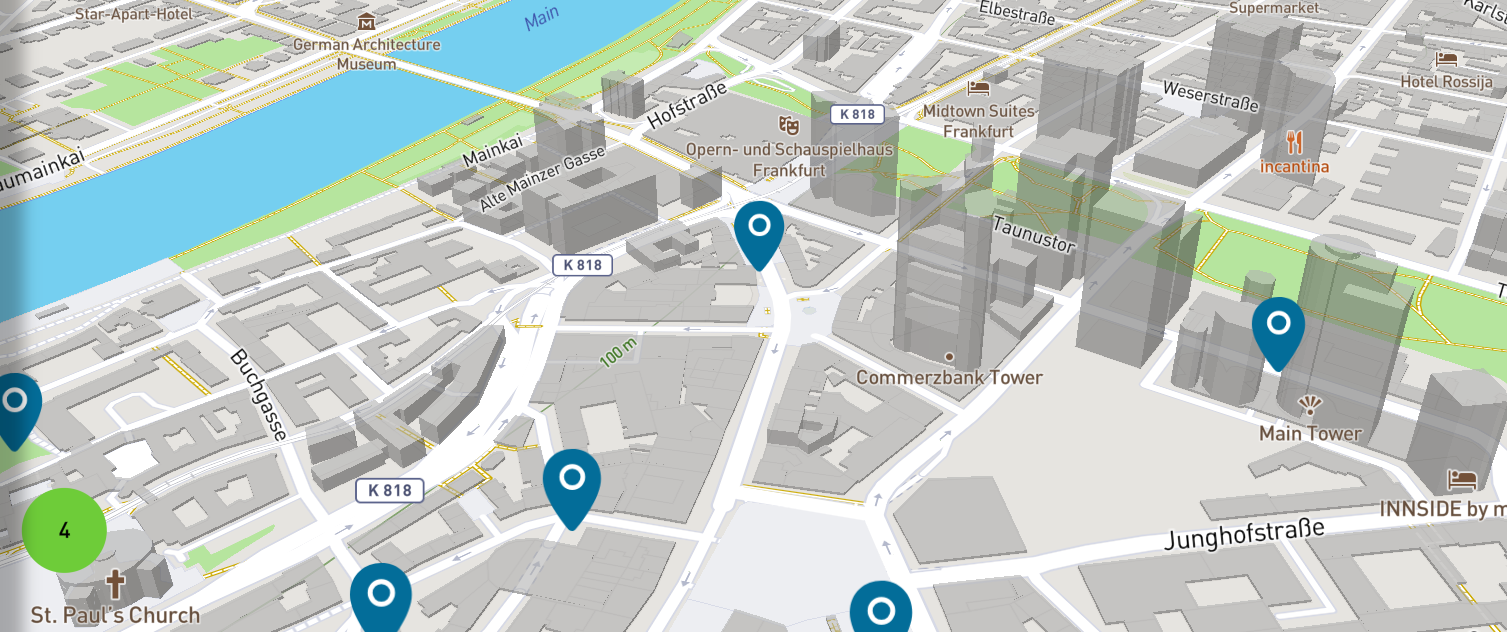
You also need to specify the location of the trail. To do this, simply click on the correct location on the map.

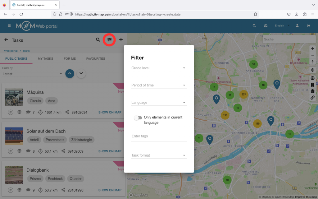
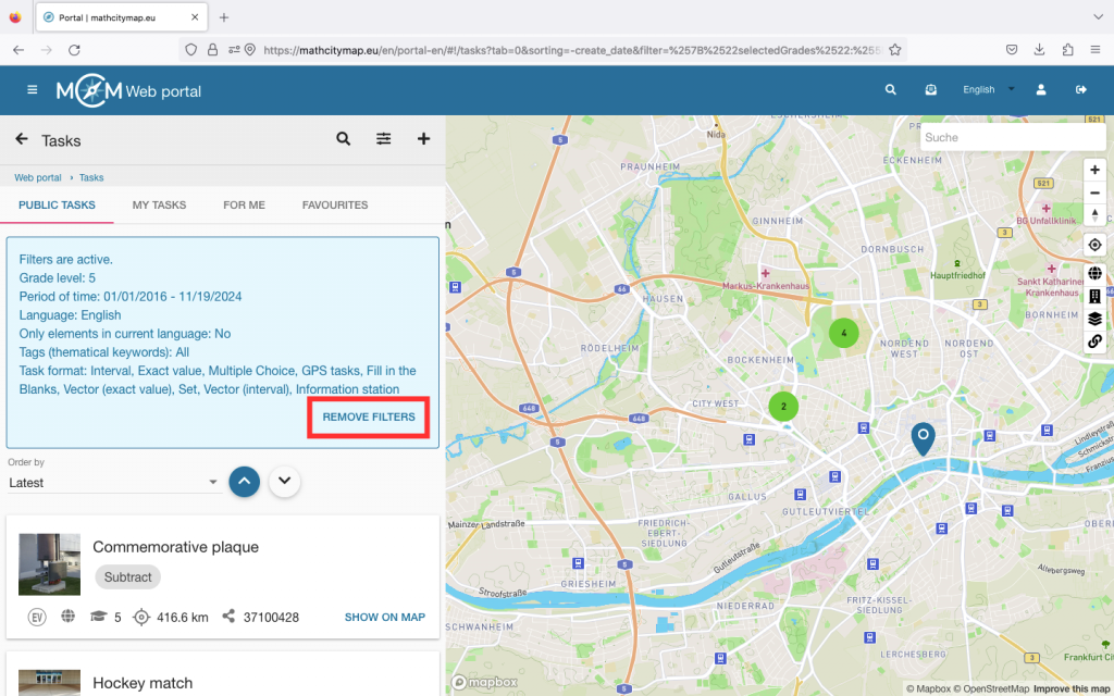
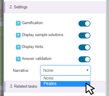
Various settings can then be activated or deactivated. Clicking on the “i” explains what the settings are for. By default, all applications are activated. They can be deactivated by clicking on the slider on the right-hand side.

Now click on “Create”. You can then add tasks.
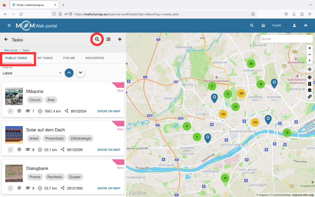
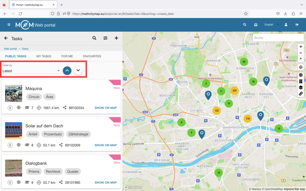
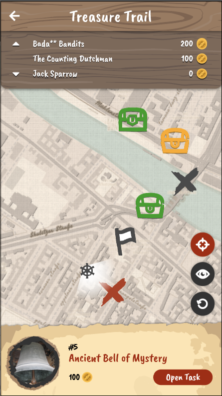
Step 3 – Add tasks

Now click on “Add tasks” and select suitable tasks. Under “Tasks nearby”, you will be shown tasks that are located near your selected location for the trail. If you have created your own tasks for the trail in advance, you can also search only for these by clicking on “own tasks only”.

Click on the green plus on the right-hand side to add tasks or on the red cross if you want to remove them again.

Then click on “Yes” under “Save changes” if you want to add the tasks to your trail.

You can now find the trail with the added tasks under “Trails – create and manage” under “My trails”.

Step 4 – Edit trail

If you want to make subsequent changes to your trail, click on “My trails” in the trail area and select the trail you want to edit.

If you want to add new tasks, remove tasks or change the order, click on the first icon at the top right. There you can edit the task list.

You can also change the general information, such as the title. To do this, click on the second icon.

Click on “Save” to save your changes.

Further Tutorials

Create / Edit a New Task

You can create your own mathematical tasks in the MathCityMap web portal. Here is a step-by-step guide on how to create and edit new tasks:

Portal

Step 1 – Open the task area

To create your own task, click on the “Tasks – Create and manage” field.

You can also click on “Tasks” in the menu bar on the left-hand side.

There is a plus symbol at the top left. Click on “New task” to start creating your task. The task will not be saved automatically, so don’t forget to click on “Create” after entering the information.

Step 2 – Enter basic information for the task

You will now be asked to enter the basic information for your task.

Cover picture: Upload a picture of the place where your task is located. It’s easiest to use the QR Code. Scan it with the smartphone that you took the picture with and follow the instructions. Make sure that the task cannot be solved by the cover image alone.

Basic data: Choose a suitable title for your task. Write down a precise definition of the task and provide all the necessary information.

Position: To indicate the exact position of the task, simply click on the right spot on the map.

Step 3 – Answer format and solution

Various task types can be selected in the bar. Decide which format makes sense for your task.

For example, if you want to determine an exact number, it makes sense to ask for an exact value. With measurement tasks, small measurement errors can occur, so it makes sense to offer a solution interval here. Depending on the type of task, different solutions must be given.

Then provide a sample solution to your task. This can be in written form or as a picture.

Step 4 – Stepped hints

Up to three hints can be given for a task. These can be helpful in solving the task.

They can contain an idea or an approach to a solution or even a concrete formula or direct instructions.

To do this, select the hint type and then add a text, image or video.

Step 5 – Task meta data

Interesting information about the object of the task can be added here. For example, you can enter the year of construction of a building or exhibition information about a sculpture.

You can also specify the grade level for which the task is suitable. This is particularly important for public tasks so that MCM users know whether the task corresponds to their mathematical abilities.  

Furthermore, the required tools can be specified here, such as a folding ruler or measuring tape.

Finally, you should define certain keywords. These also help other MCM users to decide whether they want to solve the task or not. To do this, enter a term and confirm it by pressing the Enter key.

Your own name is automatically entered as the author. The e-mail address of the linked account is also listed there, but it is not visible to others. Finally, click on “Create” and your task is created in the web portal.

Step 6 – Edit tasks

f you want to edit your task later, go to “My tasks” via the “Tasks – Create and manage” field.

Select the task you want to edit. You will then see an edit icon at the top right. If you click on it, you can adjust the cover image, basic data, position and meta data afterwards.

Click on “Save” at the bottom to save your changes. 

Further Tutorials

Finding tasks outside

To find suitable mathematical tasks outside, you should look for certain objects in your environment that are well suited for mathematical questions. Here are some steps you can follow when looking for suitable objects and questions:

Portal

Step 1 – Recognize suitable objects

Look for objects with clear geometric shapes or fixed dimensions, such as rectangular buildings, round fountains or linear paths.

You can also use natural features such as trees, plants or hills.

Road signs, distance markers or other markings in the environment also often provide valuable data for mathematical questions.

Schritt 2 – Fragestellung

Make sure that your question also requires an activity. In order to solve the task, you have to estimate, observe or measure and also calculate.

You should therefore not choose objects where you can already read off the solution.

Further Tutorials

Search and filter public tasks

You can find public tasks that have already been created in the MathCityMap web portal. The search for suitable tasks can be narrowed down using various filters. Here you will find a step-by-step instruction on how to search for and filter public tasks in the web portal:

Portal

Step 1 – Accessing public tasks

To search for public tasks, click on the “Tasks – Create and manage” field.

You can also click on “Tasks” in the menu bar on the left-hand side.

A page with your tasks will open

Step 2 – Search for tasks

Click on “Public tasks” to search for specific math tasks that are publicly available.

The magnifying glass symbol allows you to enter keywords that should be in the title of the task.

Step 3 – Sorting tasks

The tasks can be sorted in ascending and descending order according to three different criteria: by creation date, by distance from the current location and by class level.

Step 4 – Filter tasks

There are various options for narrowing down the search using the filter symbol.

Grade level: select the grade level for which you want to find suitable tasks.

Period: select the period in which the task should have been created. 

Language: filter the tasks according to the availability of languages or activate the slider if the tasks should be in your own language (which is selected in the web portal).

Topic: If you are interested in a specific mathematical topic, you can enter it as a tag. This will only display tasks on this topic.

Task format: select which answer format your task should have.

Step 5 – View results and open tasks

The selected filters are displayed in a blue box above the tasks.

If you want to reset your filters, you can click on “Remove filters”.

After you have set the filters, the matching tasks will be displayed.

Click on a task from the list to see more details.

Further Tutorials

Generic Tasks: Velocity

The new article on Generic Tasks is dedicated to a task from the ” Velocity ” category. With the help of the task wizard, this task can be created in the shortest possible time, as always, and the corresponding object can be found everywhere in your environment, especially in urban areas. You can read the […]

Generic Tasks

The new article on Generic Tasks is dedicated to a task from the ” Velocity ” category. With the help of the task wizard, this task can be created in the shortest possible time, as always, and the corresponding object can be found everywhere in your environment, especially in urban areas. You can read the first article on Generic Tasks, which also tells you how to get to the task wizard and what Generic Tasks are, here.

The object we are going to look at in this article is escalators. They are often found in public buildings or at the entrances to subway stations or train stations. The task that is available for escalators in the task wizard is:

“Determine the speed of the escalator. Give the result in meter per second. Give the result with two decimal places.”

Required for creating the task are the time duration, which the escalator needs to travel a well-defined distance. In addition, you can select whether the speed should be specified in m/s or in km/h. Based on the entered data, the wizard fills in the rest of the task form and only a picture needs to be added to complete the task.


In the next article we will deal with the probably most special category of Generic Tasks, the so-called GPS tasks. Until then, have fun and save time when creating MCM tasks with the Task Wizard!


Trail of the Month: Un paseo pirata matemático

Our new Trail of the Month is located in Alcobendas, Spain. The trail in the town north of Madrid has been frequently used in teacher practice, as shown by the high number of more than 230 downloads. It was created by José Fernández de la Cigoña and Isabel Docampo for presenting MathCityMap during the Spanish […]

General

Our new Trail of the Month is located in Alcobendas, Spain. The trail in the town north of Madrid has been frequently used in teacher practice, as shown by the high number of more than 230 downloads. It was created by José Fernández de la Cigoña and Isabel Docampo for presenting MathCityMap during the Spanish mes de las matemáticas (month of mathematics; click here for the website and here for our report on the project).

In the following interview, José Fernández de la Cigoña highlights the use of the MathCityMap pirate narrative and introduces her trail Un paseo pirata matemático por el Jardín de La Vega”.

How do you get in contact with MathCityMap?

We got in touch with MathCityMap by the Spanish website Marzo, mes de las matemáticas from whom we were asked to prepare a trail to contribute to the month of mathematics. So, we looked for some information, signed up for the MathCityMap MOOC and started creating on our trail. We aim at a broad revision of learned topics, mainly geometry but also divisibility, probability or proporcionality, among others. 

Our students in school have already worked on the trail! In fact, we are a little surprised by the high number of downloads of our trail by other users.

Please describe your trail.

Our trail is placed in a park in Alcobendas, a city close to Madrid. The website Marzo, mes de las matemáticas guided us on the kind of tasks we could look for, and one great characteristic of this trail is that most of the tasks can be easily recreated in any city around the world [so-called Generic Tasks]. The special attribute of this trail lies in a story connecting all the tasks, a sort of pirate adventure based on the MathCityMap pirate narrative.

Please sketch one of your tasks. What is the mathematical question? How could you solve it?

The most inventive task in our trail is “La batalla final” (The final battle). It is located on a playground where you can find a pirate ship. The aim of the task is to find the probability of hitting the ship if you fire a cannon. So it’s about probability and geometry since you need to evaluate the ship area and the area of the playground to know the probability.

Why do you use the pirate narrative. What are its benefits?

Since we have been developed a pirate story, it seemed so natural to use the pirate narrative. In fact, this narrative inspired us to create the story.


Spanish Month of Mathematics with MCM

MathCityMap is broadly disseminated in Spain: In addition to our long-term partner FESPM, a teachers’ association, our project is now also promoted by the initiators of the mes de las matemáticas (month of mathematics) in Spain. For this purpose, in cooperation between mes de las matemáticas and the FESPM, seven trails have been created, three […]

General

MathCityMap is broadly disseminated in Spain: In addition to our long-term partner FESPM, a teachers’ association, our project is now also promoted by the initiators of the mes de las matemáticas (month of mathematics) in Spain.

For this purpose, in cooperation between mes de las matemáticas and the FESPM, seven trails have been created, three of them for primary school children and four for secondary school children. Four of the new math trails are located in Malaga near the Costa del Sol, and two others in Jaén, Andalusia. The seventh and last math trail, which was created as part of this project, was created in Alcobendas near Madrid. We will present it to you in May as Trail of the Month.


List of the new math trails:

Portal Update: Synchronization between map and list

The October update includes some changes to the web portal. An essential point is the synchronization of list and map view. What does that mean? Previously, the tasks and trails that were visible on the map were not necessarily part of the list. As a result, the list displayed content from different places and possibly […]

The October update includes some changes to the web portal. An essential point is the synchronization of list and map view. What does that mean? Previously, the tasks and trails that were visible on the map were not necessarily part of the list. As a result, the list displayed content from different places and possibly different languages.

With the new update, the currently visible map section is linked to the list. Accordingly, only tasks and trails can be seen in the list that can also be found in the current map section. This has the advantage of obtaining relevant data for your location. In addition, much less data must be loaded, which increases the speed of the web portal.

If you want to get an overview of all your tasks, a button (globe icon) on the right edge of the map will help. This zooms on the whole world and thus represents all your content.


Overview of further changes:

  • New 3D map: The MCM web portal now uses new map technology. This allows you to tilt the map (hold right mouse button and move mouse) and show or hide 3D buildings. The following actions can be performed via the control bar on the right side of the map (from top to bottom):
    • Zoom map (Zoom in)
    • Zoom map (Zoom out)
    • Align to the north
    • Show and center your own position
    • Show entire world map (zoom out to maximum)
    • Show or hide 3D buildings
    • Change map style (Street, Outdoors, Satellite)
    • Loading Indicator (indicates whether data is being reloaded)
  • Revised trail and task preview: Content does not open directly on the first click. Instead, a content preview based on the MCM app opens first.
  • Create or edit a trail: If you open the details of a trail, the list and all other trail pins will be hidden. When switching to edit mode (or when creating a new trail), tasks (Own and Public) in the current map are added to the map, which can then be assigned to the trail. In addition, these tasks also appear in the list. This makes it possible to create a trail using the list. The various sorting options can help keep track of a large amount of tasks.
  • Customization of task and trail pins: The MCM web portal now uses the same pins as the MCM app. Tasks are represented by rounded pins. Trails are represented by square pins. In addition, there is a color and a symbolic distinction:
    • Dark Blue: Own content (created by logged in users)
    • Blue: Foreign (public) content (created and shared by another user)
    • Light Blue: Selected content (eg pin-click to preview or if details are open)
    • Circle icon (currently only trails): Public Trail
    • Key Icon (currently only trails): Private Trail
    • light blue (transparent): Occurs when working on a task and represents the previous task item.
    • Note: The colors will be adjusted and optimized in the near future.
  • New Tasks Wizard – Age of the tree: The task wizard has been extended by another template. The task deals with the calculation of the age of a tree from measured circumference (in cm) and given growth factor of the diameter (in cm per year). At present, there is a wide choice of trees in Europe, such as maple, birch, beech, oak, etc. This task can be found under the category “growth”.
  • Sessions: Running paths are no longer collectively displayed on the map. Instead, each user will see their own track based on their events as soon as they click on the user (list or map). In addition, the events are marked as small circles on the map and can be clicked for more information. It is now possible to retrieve the path of a user later.
  • Review: The review process has been partially changed and adapted:
    • Logged in users can view the review history for their own tasks and trails.
    • If a trail was rejected and a user tries to re-submit it directly, an error message appears. The error message says that first the feedback of all rejected tasks of the trail must be read and confirmed before a re-submission is possible.
    • Reviewers must now leave a message to complete a review.
    • A trail can only be published if none of the tasks have recently been rejected.
    • Reviewers will now receive a quick feedback as soon as they have made a decision.
    • If a trail is submitted for publication, a reviewer can now see all the tasks of the trail, even if they do not need to be reviewed. In terms of color, these are coded as follows:
      Light blue opaque: Task Waiting for Review
      Light blue transparent: Task has already been published
      Red: Task has already been rejected
  • Other changes:
    • Trails can now be sorted by downloads
    • New trails are highlighted in the list with a green star
    • GPS tasks now use a small red circle instead of large pins to mark positions. In addition, hints were added on how to set markers or coordinate system.
    • Extract position from images: If you upload an image for a task and it contains position data, a message appears asking if the user wants to use the image position to set the location of the task.
    • If the portal is called with an extended URL that points to a content, the user can choose to jump to that content or start the portal as usual.
    • Many alerts have now been replaced with more user-friendly custom alerts.
    • Bugfixes when creating sessions: If a session exceeds the permitted duration of 48h, an error message appears, which prevents the creation of the session. Furthermore, an automatic task assignment error was corrected in Custom mode, where the task titles were not displayed.
    • Fixed an error when changing the share for a group.
    • Updating frameworks (AngularJS, FontAwesome)
    • Small bug fixes and style adjustments

Portal & App Update: Narratives

Ahoy mateys! A new exciting feature for MathCityMap is now available both in the App and Web portal – Narratives. Narratives carry the app users away to new thematic settings. The route creators can optionally enable a specific narrative for each of their routes, the narrative gets automatically applied and can be experienced after downloading […]

Ahoy mateys! A new exciting feature for MathCityMap is now available both in the App and Web portal – Narratives. Narratives carry the app users away to new thematic settings. The route creators can optionally enable a specific narrative for each of their routes, the narrative gets automatically applied and can be experienced after downloading the route in the App.

The App’s text (such as task descriptions, hints, answer feedback, etc.), is replaced or expanded with dialogue lines from the narrative assistant: a companion that travels alongside the player and aids in their quest. The App’s graphical elements (banners, backgrounds, the map, etc.) are replaced with elements allusive to the narrative.

Our first narrative: Pirates!

And so, we present the first narrative: Pirates!

In this narrative the player is a pirate Captain that seeks to collect as many coins as possible and find the trail’s treasure! They are accompanied by their trusty parrot, Perry. Perry will help them solve riddles, getting them closer to the treasure one enigma at a time. When all the riddles are solved, the Captain finds the treasure!

To enable a narrative on a route, go to: Portal > Routes > My Routes and select the route. Then, on the route’s details click “Edit”, scroll down to the “2. Settings” tab and select the desired narrative from the dropdown list. After this, you just have to click “save” and the narrative will be applied. From that point on, when users download your route, they will have a new adventure awaiting for them.

New Graphics

The trail is now represented by a treasure map

Companion

Perry the parrot accompanies the player on his adventures.

Enabling narratives

In the section “2. Settings” select a narrative from the dropdown menu.

Our objective is to provide the MathCityMap App users with fun experiences that feel distinct, fresh, but still follow the general flow of the original math trail solving experience. As such, narrative routes will immerse the users in a small story and improve their motivation to continue solving the tasks and try even more routes.

Other changes

  • Introducing LaTex to MCM (App & Web): Writing mathematical formulas with the computer is not always easy. For a long time we have planned to support LaTex formulas in MCM. Finally, this feature is available to all users through the integration of the MathJax library. Find a documentation here.
  • Click images to enlarge (App): Images such as the title image, hint images or sample solution images can now be viewed and zoomed in a separate view, just click them.
  • Minor bug fixes.

User Survey 2019

Update 09.09.2019: The questionnaire of our user survey will be open until Sunday. We appreciate your feedback on MathCityMap to improve the system. Our web portal and the app went through major changes during the last year. Technically, we implemented new features, the layout changed, the community has been grown and so did the number […]

Update 09.09.2019: The questionnaire of our user survey will be open until Sunday. We appreciate your feedback on MathCityMap to improve the system.

Our web portal and the app went through major changes during the last year. Technically, we implemented new features, the layout changed, the community has been grown and so did the number of tasks and trails. Thanks to you as active members of the MCM community, there are MCM tasks in more than 40 countries! Moreover, we are interested in how you work with the system and what your experiences are. Therefore, we created a little online survey and kindly ask you to participate. 

Link to online survey

We appreciate your feedback on MathCityMap to improve the system.


Best wishes
The MCM-Team